Monday, 7 December 2020

Our newest team member, YiTin


Here at F!nd, were extremely excited to welcome our newest member to the team, YiTin.


YiTin has three years of work experience as a GIS data specialist. Before joining F!nd Maps, she worked for the Greater London Authority, promoting data transparency in Planning.

YiTin’s professional duties within the F!nd team will include database management, data update and map creation. She will also be responsible for liaising with data suppliers and dealing with data requests.


YiTin enjoys cooking and travelling. She is also a cat person although she doesn’t own one.

Tuesday, 21 April 2020

OS Open Map Local Styling

This second Find data blogpost is to explain how Ordnance Survey created a stylesheet to make the Open Map Local backdrop style map not only visually pleasing, but easy to understand as well


Stylesheet is code that, when applied to geographic data, determines the visual appearance of the content. Once added in Geoserver and connected to the relevant layers, a proper map can be displayed through a WMS feed.


To style OS Open Map Local in the ‘backdrop’ theme, different stylesheets are requested for each layer depending of geometry and classification - building, river, road, etc. In this blogpost, polygon with building, line with road and points with London Underground logo will be presented and explained.

Building:
For building, the stylesheet is simple with just minimum and maximum scale limit and color defined by HEX code color.

Road:

To style line data as roads, minimum and maximum scale rules are used. The rule for A Road is defined with the LineSymbolizer. Color is specified via HEX code color, width of line in pixel (12 pixels), stroke-linecap parameter renders the ends of line as rounded instead of flat and the stroke-linejoin parameter renders the junction with other line as rounded.
 
Label is set with TextSymbolizer with different parameters: Font, LabelPlacement, Halo, Fill, VendorOption.

Font set identifies font family, font size and font weight.
LabelPlacement set defines label position in regard to the line in pixels. In the case of A Roads PerpendicularOffset is set to the default, which is 0. A positive value displaces upwards, a negative value downwards.
Halo set characterizes a halo around the font with radius in pixels and fill with HEX code color.
Fill set identifies label color with HEX code color.
Vendor option sets is a Geoserver specific option composed of multiple parameters.
  • spaceAround allow labels to overlap (negative value) or add extra space around labels (positive value)
  • followLine forces the labels to follow the curve of the line
  • Group allows display of a single label for multiple features in a logical group
  • maxAngleDelta sets the maximum angle, in degrees, between two characters. Used in conjunction with followLine.
  • maxDisplacement controls the displacement of the label along the line. This option avoids conflict by using alternate location with pixels along the line.
  • Repeat defines how often a label is displayed along a line.

London Underground Station:

To style a point with the London underground logo, the stylesheet uses a link to an external SVG file which contains the London underground logo. In this case only minimum and maximum scale are determined and SVG size. This method can be used for any complex object that cannot be created using standard stylesheets.


Monday, 6 April 2020

Paper Map Beads

During the ongoing lockdown, our staff have been looking for ways to keep entertained and we thought this was such a good idea, it might be useful as an activity for your families...


We used an old OS map to create our beads, but they can also be done using pages from an old magazine.


Cut the page into long thin triangles


Tightly wrap the paper around a pencil of similar.


Have fun! 

Wednesday, 25 March 2020

Coronavirus (COVID-19)

As you will be aware, the Prime Minister addressed the nation on Monday night, to announce some important and necessary measures in the fight against Coronavirus (COVID-19).

Our offices are now closed, but we are working tirelessly from home to keep our services running to our highly valued customers.

If you need any help or support over the coming weeks, please contact us via telephone or email:

Support: 0845 521 1410
support@findmaps.co.uk


Please take care of yourselves.

The F!nd Team 

Thursday, 13 February 2020

Long time... No sea...

We are happy to introduce you to our new and improved range of data services. Get in touch with our team now at marinesupport@findmaps.co.uk and we’ll find a solution that suits your business.
Simply:

1. SELECT AREA OF INTEREST
2. CHOOSE YOUR DATA PRODUCT
3. SELECT NUMBER OF USERS
4. CHOOSE LICENCE PERIOD
5. DATA DELIVERY

It really is as simple as A, B, Sea...


Monday, 3 February 2020

Utility Reports (STATS Reports)

As well as mapping and data for your projects, did you know FIND also supplies utility reports?


Rather than contacting individual utility service providers for up-to-date plans, save time and hassle by using FIND.  We’re a one stop shop.  All we need from you is a location and/or a plan showing the boundary of your area of interest.  We’ll quote for exactly what you want, start your searches immediately you confirm an order and deliver a completed report direct to your desktop.


Our service is convenient, reliable, competitively priced and tailored to your needs.


Thursday, 19 December 2019

All I want for Christmas...

With Christmas fast approaching, we thought we would ask the team what they're hoping Santa brings them on Christmas Morning...

Pamela

What is on your Christmas List Pamela? Good food, good wine and good company.
Are you on the good or naughty list?! I think I’m on the ‘could do better’ list.

Jon

What is on your Christmas List Jon? I discovered this year that I actually have a hat face, so a nice fedora would be well received
Are you on the good or naughty list?! Have you seen me? Face of an angel!

Manon

What is on your Christmas List Manon? Enjoying time with family and friends, cooking the Christmas meal and going to a Christmas Market at some point.
Are you on the good or naughty list?! Definately the good list ðŸ˜Š


Our Office closes on Tuesday 24th December and reopens on Thursday 2nd January.

Merry Christmas 

Sunday, 15 December 2019

Feeling Festive @Findmaps

It was our annual Christmas get together at the fabulous Punch Tavern on Fleet Street last week. With delicious food and over 50 gins on the menu, it's no suprise that a good time was had by all!


Merry Christmas to all of our wonderful Customers!

Sunday, 3 November 2019

The first in the series of Find Data blog posts - VMD FME Update

Welcome to the first in the series of Find Data blog posts! Here we will take an in-depth look at the many and varied datasets which Find acquires, processes, loads and supplies in various ways to our many excellent and demanding (in a good way!) clients. We are of course partnered with the best and biggest data suppliers in the UK (OS, BGS, EA, Land Registry etc.) but just how do we take their often quite raw data and easily create consumable data feeds for our wonderful customers? Read on to find out more....
OS VectorMap District - 1:25 000 backdrop mapping

  1. About the data 
OS VMD (Ordnance Survey VectorMap District) is a free mapping dataset providing contextual backdrop mapping. The data can be displayed as vector or raster covering the whole of Great Britain. It is updated biannually in May and November. 
The dataset is available to download online in its raw format as shapefile, GML or TIFF: 
Styling is also provided with 2 different options, backdrop or full color:


VMD is provided, as with all OS mapping products, in OSGB36 (EPSG: 27700) coordinate referencing system. 
OS VMD data are divided for whole UK into squares 100km by 100km with unique two-letter reference. Each tile is then split into 20km by 20km tiles. 


  1. VMD used by FIND mapping
FIND downloads the full UK OS VMD dataset as GML feature type format and then loads it into a PostGIS enabled Postgres database. 
OS VMD data is provided as WMS using Geoserver. Customer can then access to OS VMD WMS as contextual mapping background. 

  1. FME workspace process 
To create a WMS (Web Mapping Service) feed of the OS VMD dataset from the raw GML files requires multiple loading and processing steps. Read on for the full step by step explanation of how we load OS VMD and make it available for all our customers. 

To load OS VMD into our database, we made the choice to use FME. It is a powerful software to load, transform and display huge datasets such as OS VMD. OS VMD is converted from GML files to be loaded into the FIND Postgres database using FME.
First, we save all the GML files in the same folder to be able to load it in FME. 

  • Step 1
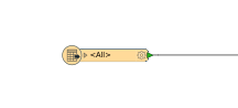
Load OS VMD data as one GML single merged feature reader in FME

 
  • Step 2 
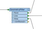
Filter attribute by geometry (point, line, polygon) with GeometryFilter transformer


  • Step 3 
 Filter attribute by feature type for each geometry to create 21 output tables with AttributeFilter transformer


    • Administrative Boundary - Railway Tunnel
    • Building - Road
    • Electricity transmission Line - Road Tunnel 
    • Foreshore - Roundabout
    • Functional Site - Spot Height 
    • Glasshouse - Surface Water Area 
    • Motorway Junction - Surface Water Line
    • Named Place - Tidal Boundary 
    • Ornament - Tidal Water
    • Railway Station - Woodland 
    • Railway Track

  • Step 4
Add Counter transformer to create ID column with unique number 


  • Step 5 
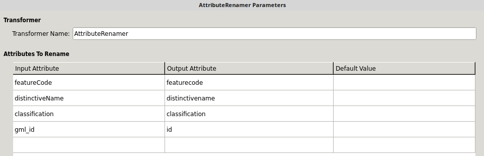
Connect reader and writer attribute with AttributeRenamer transformer to create the right output table with right column, column name and attribute.

  • Step 6 
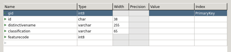
Load the output writer with the right column names and types into Postgres. This step is important. Column names and types must be same as recommended in OS documentation to be showed correctly the WMS. 

  • Step 7
Run the FME workspace. This takes around 9 hours. 


  1. Load OS VMD in Geoserver 
Once OS VMD dataset has loaded we do a manual check in the Postgres database. Geoserver can then be used to display data as WMS to be accessible for customers. 
We always check the styling, because OS periodically update it, it is highly recommended to load the new VMD styling whenever OS VMD is updated: https://github.com/OrdnanceSurvey/OS-VectorMap-District-stylesheets

  • Step 1 
Open the .SLD style file in notepad and have a look at the column name to confirm that is the same as your new OS VMD layers (be careful with capital letters and data types) 
Load all 21 new stylings in Geoserver. 


  • Step 2 
Load 21 OS VMD layers from Postgres. Tick “compute from native bounds” to update the coordinate system and load relevant style previously load. 
  • Step 3
Visualize each OS VMD layers with OpenLayers in Layer Preview menu. This step allows to check if layers are displayed properly using the relevant style. 
  • Step 4
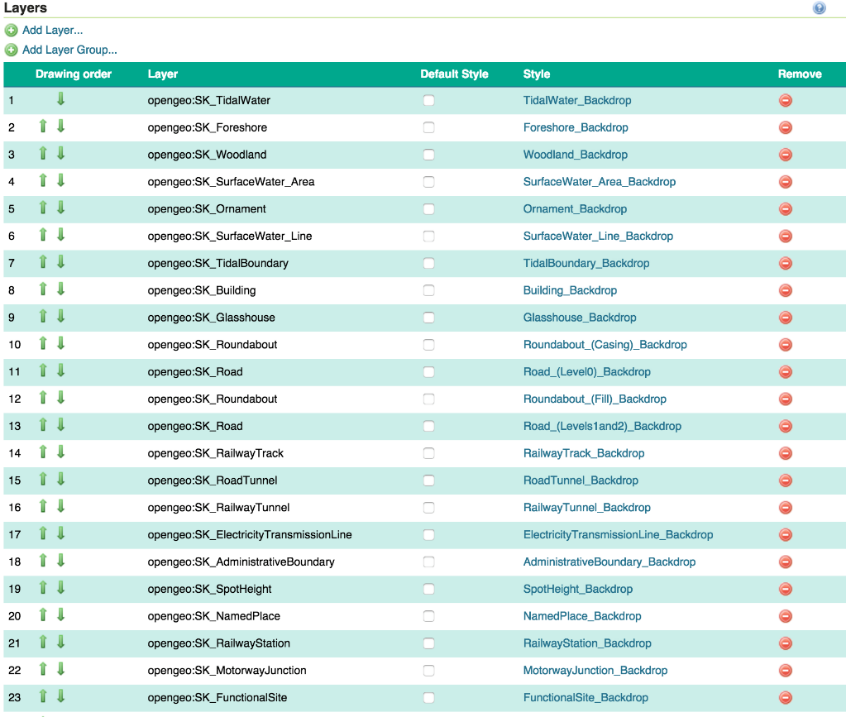
Update or create a Layer Group with OS VMD layers and styles following OS recommended layer ordering.
OS VMD is now ready to go as a WMS feed and available to stream in the normal fashion using a simple URL.

Friday, 1 November 2019

Halloween Antics @Find HQ

Things were quite spoooooky here at Find HQ yesterday

The day started off well, all colleagues were joining in the fun...


 But things took a terrifying turn when all the chocolates were eaten...


  • We witch you a Happy Halloween, and hope it doesn’t suck like a vampire!!