
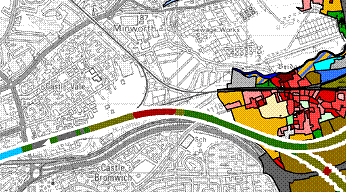
Above, PDF of a background map with several geo-datasets layered over the top, including the proposed HS2 rail route through Warwickshire, property locations and ownership.
This will have a considerable impact on the area a major consultation is planned for next year. Following a chat with Mariam Crichton, Director of FIND, the team at Warwickshire County Council became excited about the prospect of using PDF mapping layers to inform that consultation process.
The team produced layered maps showing the proposed route of the rail link through the county. The maps show the locations of WCC property, ecological, archeological and historic landscape sites along the route. Also, the maps link to the detailed plans on the HS2 website.
Because PDF maps can be viewed regardless of hardware or operating system this makes them extremely accessible to the general public. In addition, they can be applied and viewed either individually or built up in layers. This gives much of the functionality of a sophisticated online mapping system, but at a fraction of the cost.
Using maps in this way has not only enabled the team at Warwickshire to inform the public about plans and the development of those plans, it has also allowed a broad range of interested parties to become involved in the process. The maps have also prompted people with detailed local knowledge to give valuable feedback.
One of the team told us, "PDF maps have been of great help. We have had incredible user feedback from the public. It's a fantastic way to provide a wealth of mapping data in an easy to understand, accessible format. Users have even identified flaws which we have been able to correct."
At FIND we are delighted that the GIS team at Warwickshire County Council has used PDF mapping in such an innovative and imaginative way. Their work has helped to show the public what a powerful tool it can be.
HS2 WCC website
I never thought that PDF could be used for maps and layering. Actually there is still a part of me which does not understand how this can be possible on the traditional PDF platform. I guess unless i see it in action, i will not be convinced. Personally, i have found the Adobe Illustrator to be an extremely useful tool for the maps and layering. It allows you to generate a JPG at the end of the design phase and this can be easily shared. But love your idea. And i am sure that it wont be the first time it will be used.
ReplyDelete